Seng Kut Snem

Seng Kut Snem, the name of a much vaunted festival of the Khasi community festival in Meghalaya plays no less role to boost revenue in the north eastern state. This is an occasion of these tribal people in the month of December to preserve and exhibit their age old culture and tradition. It further aims at highlighting the religious significance of the Khasi people across the country.  Funs and frolics, traditional Khasi dance and music make the occasion more colourful. Traditional sports and games are also allowed to be a salient feature of the festival. Dressed in traditional Khasi attire, the tribal youths dance accompanied by drums and flute, striking major attention of the tourists from the country and abroad.  This is what their safe way to preserve and safeguard the indigenous way of life (Niam Trai Niam Tre).

Venue: Shillong

Date
Location/Venue

Shad Suk Mynsiem at Weiking

The Khasi tribe in Meghalaya is known for their unique tradition and culture. They don’t have any dearth of occasions to showcase their culture before the world. Mention may be made of the Shad Suk Mynsiem. The spring festival falls on April 13, 14 and 15 where they offer prayer to the god for bounteous harvest. Spotlight falls on the Weiking grounds near Shillong.  

They further make it an occasion to showcase their culture dancing to the tune of traditional drum beats and pipes. That’s why, the Khasis call “Shad Phur” as “Shad Suk Mynsiem” a thanks giving dance to the god who ensured a bounteous harvest in the season. It further highlights the unique matrilineal and patrilineal system of the Khasi tribe.

The tourists take delight when men at the venue whip and sword circles the unmarried female counterparts to play the role of a protector of the womanhood having a single strength and resource. The men have twelve strength and resource in them. The dance stands for ritualistic and symbolic of fertility cult which takes place at Raid and Hima village level. That’s the main attraction of the three day long spring festival.  

Their traditional dresses and jewelries are charming. The female dancers wear cloth draped from waist to ankle (Ka Jingpim Shad) with full sleeve blouse with lacework at the neck (Ka Sopti Mukmor). The necklace is made of red coral and foil-covered which they call “U Kpieng Paila”. The golden ear-rings known as Ki Sohshkor Ksier make the costumes more charming.

The male counterparts wear golden silk turban which they call “Ka Jain spong Khor”. These are in addition to the semi-circular collar of gold-silver plate tied round the neck “U Shanryndang”. More charming is their maroon silk cloth worn like a 'dhoti' with a ceremonial   sword.

Date
Location/Venue

Wangala Dance Festival

Wangala Dance Festival

A honeyed golden November sunshine turns Meghalaya in to a haven misplaced on the planet. The entire north eastern state wears a different look marking the advent of the winter season. That’s an ideal turn for the Garo people in Tura to celebrate the Wangala Dance festival.

Festivity grips Asanang near Tura town on November 12, 13 and 14 where traditional dance and music are showcased. The striking feature of the weeklong festival is the music apart from the orchestra of drums, gongs and flutes. A traditional flute made of buffalo horn makes the festival more charming.

The festival begins after a Nokma performs a ritual with fresh rice-beer, rice and vegetables seeking divine help from Misi Salong for a bumper harvest. Also known as 100 drum Wangala festival, marks an end to the unrelieved toil in the paddy field. 

With the passage of time, Wangala Festival has undergone some changes where the age old Garo traditions have amalgamated with modern life styles of these people in Meghalaya.

The festival begins as soon as ten Wangala Dance troupes arrive the venue from the various parts of the Garo Hills. Drums are played in a rhythmic manner when the participants move in lines much to the delight of the tourists who throng the venue to share the joy.

Date
Location/Venue

Behdienkhlam festival

July in the Jaintia Hills districts of Meghalaya is a season of festival where local people find an occasion to showcase their traditional culture. The annual festival of the Pnara tribe begins on July 15 to conclude on July 20. Known as Behdienkhlam, the religious festival beckons huge number of tourists from the country and abroad. Jowai, locating at an altitude of 1220 metres from sea-level and only 64 km. away from Shillong by road, in the north eastern state wears a fresh look where the youths celebrate the festival with traditional dance and music.

The most striking event takes place on the final day where the Pnara boys and girls throng Aitnar and dance to the tune of their traditional drums and pipes. The participating boys and girls surround a wooden post at a pool they call khnongs and start dancing with all joy.

Organized by Seinraij Jowai after the sowing season, another attraction of the festival is a football-like match which they call dat la wakor to be played between two groups from two different sides of the non Christian Pnara-dominated places. The match predicts the entire harvest season. The first goal scorer would be considered to be the winner of a bumper harvest.

According to what the Pnara people believe, “Behdienkhlam” tands for driving away the plague. “Khlam” means ‘Plague.’

Those who believe in niamtre from Iongpiah, Dulong, Panaliar, Loomkyrwiang, Chilliangraij, Loomiongkjam, Tpep-pale Iawmusiang, Ummulong and Shillong Sein Raij bring a nice-decorated chariot to Aitnar where the festival is celebrated to help them overcome the destructive and to keep the diseases at bay.

They jump on the poles and sometimes break them while dancing on the huge muddy pool. The women are not allowed to participate in the dancing.

Date
Location/Venue

Nongkrem Dance Festival

The entire Khasi hills in Meghalaya erupts in joy as soon as the Nongkrem dance festival falls. The week long festival takes place on November 1 where the festivity of the Khasi hills people knows no bound. The carnival is all about wealth, animals and an environment. Animals are sacrificed as part of the festival to be followed by feast along with songs and dance. The central place of attraction is Smit, the fixed venue of the occasion where the Khasi hills people throng to participate in the event which is 11 km away from the capital city of Shillong, an ideal place for the tourists. Initially, the Khasi people called it Ka Pemblang Nongrem. But they replaced it with Nongkrem dance Festival of Meghalaya. The salubrious festival comprises fairs, songs and dances, mostly, to appease the goddess Ka Blei Synshar to ensure bounteous crops. The striking part of the festival is the Pemblang ceremony. Performed by the Syiem of Khyrim along with the high priest, the principal event takes place by sacrificing an animal in the name of Lei Shyllong. The god of Shyllong peak by gets a cock. The ancestors of the ruling clan also share the puja offerings in the Nongkrem dance festival.

Date
Location/Venue

TYRSHI FALLS Jowai-Shillong Road, West Jaintia Hills, Meghalaya

TYRSHI FALLS Jowai-Shillong Road, West Jaintia Hills, Meghalaya

Situated on the Jowai-Shillong road of Meghalaya, Tyrshi Falls is a delightful waterfall in the Jowai region. Just like the Elephant falls in Shillong, Tyrshi falls is known as the Elephant falls of Jowai where one can take the joy of going close to the waterfall and enjoy the water bursts. But however, mention must be made of the fact that Tyrshi falls is three times taller than the Elephant falls.

Lush green paddy fields adorn this beautiful waterfall. The fall comes down in steps with the water flowing swiftly in a gush. An arched bridge, consisting of 20 hundred steps go down to the bottom of the falls. One can enjoy an incredible and scenic view of the Pynthor Nein (paddy fields). The best time to visit this place would be during the monsoon period. But one can visit Tyrshi falls throughout the year.

How to reach: 

Nearest airport is the Guwahati Airport. Helicopters are available from Guwahati to Shillong. Nearest railway station is Guwahati railway station, which is 176  kms from Shillong. By road, Guwahati to Shillong is 99.5 kms via NH 40. Jowai is at a distance of 36 kms from Shillong. Tyrshi Falls is 5 kms from Jowai.

Best time to visit: 
Monsoon period / Throughout the whole year

 
Tour Type
Location

NOHSNGITHIANG FALLS: The Seven Sisters of Cherrapunji

NOHSNGITHIANG FALLS Sohra (Cherapunjee), East Khasi Hills, Meghalaya
Audio
SoundHelix-Song-1.mp3
0:00 / 0:00

Where Seven Streams Dance Down the Edge of the World

In the mist-shrouded hills of Sohra (Cherrapunji), where clouds collide with cliffs and rainfall measures in meters rather than millimeters, nature has created one of India's most spectacular cascades. Nohsngithiang Falls—known more poetically as the Seven Sisters Waterfall—plunges 315 meters (1,033 feet) down limestone cliffs in seven distinct streams, creating a vision that has captivated travelers since the first visitors ventured into Meghalaya's wettest regions. Located just 4 kilometers from Cherrapunji town in East Khasi Hills, this natural wonder stands as both testament to the region's extraordinary rainfall and symbol of the raw, untamed beauty that defines Meghalaya.

The Seven Sisters: Nature's Symphony in Water

The name "Seven Sisters" refers to the seven segmented streams that cascade side-by-side down the precipitous cliff face during the monsoon season. Like siblings with distinct personalities, each stream follows its own path, yet they remain forever connected—parallel ribbons of white water against moss-covered rock, creating a spectacle that has earned Nohsngithiang recognition as one of India's tallest waterfalls.

The falls originate from the plateau above, fed by rainfall that Cherrapunji receives in abundance. During peak monsoon months (June to September), when the region lives up to its reputation as one of Earth's wettest places, all seven streams flow with tremendous force, merging into a thundering curtain of water that can be heard long before it comes into view. The sheer volume creates perpetual mist that rises from the valley floor, often obscuring the falls' base and lending an ethereal quality to the scene.

According to Khasi mythology, the seven streams represent seven sister spirits who transformed into water to escape an unwanted suitor, choosing to become one with nature rather than submit to an arranged fate. This legend imbues the falls with cultural significance beyond mere geological wonder, connecting the landscape to the spiritual beliefs of the indigenous Khasi people who have called these hills home for millennia.

The Viewpoint: A Front-Row Seat to Majesty

The primary viewing platform for Nohsngithiang Falls sits along State Highway 5, approximately 1 kilometer south of Mawsmai village. This accessible viewpoint requires no strenuous trekking—visitors can drive directly to the site or arrange transport from Cherrapunji town. The strategic location offers panoramic views not only of the falls but of the entire valley below, where the waters eventually join the plains stretching toward Bangladesh.

During monsoon season, the viewpoint becomes an immersive experience. Visitors feel the spray on their faces, hear the roar echoing off valley walls, and witness the raw power of water sculpting landscape. The surrounding plateau, carpeted in vibrant green during rains, provides striking contrast to the white water cascading down dark cliffs. Many travelers report the viewpoint as one of Meghalaya's most photographed locations, though cameras struggle to capture the scale and majesty that human eyes perceive.

The site includes basic facilities—a parking area, small shops selling local snacks and handicrafts, and viewing platforms with safety railings. Local vendors offer traditional Khasi items, including bamboo products and textiles, providing opportunities to support community livelihoods while enjoying the natural spectacle. The area remains open throughout the day with no entry fee, making it an accessible attraction for all visitors.

Seasonal Transformations: The Two Faces of Nohsngithiang

Nohsngithiang Falls presents dramatically different appearances depending on season, and understanding these variations helps travelers set appropriate expectations.

Monsoon Season (June-September): This is when the Seven Sisters truly live up to their name. Heavy rainfall—Cherrapunji receives an average of 11,430 mm (450 inches) annually, with most falling during these months—ensures all seven streams flow with maximum volume. The falls become a roaring cascade, with mist rising high enough to obscure views on particularly heavy rainfall days. The surrounding landscape transforms into vivid green, with countless smaller waterfalls appearing on cliff faces throughout the valley. This is indisputably the best time to witness Nohsngithiang's full glory, though visitors must contend with persistent rain, muddy paths, and occasional road disruptions.

Post-Monsoon (October-November): As rainfall diminishes, the falls maintain reasonable flow while the weather becomes more visitor-friendly. Clearer skies provide better visibility and photography opportunities, though water volume begins decreasing. The landscape remains lush, retaining monsoon's greenery while offering more comfortable conditions for exploration.

Winter and Pre-Monsoon (December-May): During these drier months, Nohsngithiang often reduces to a trickle or dries completely, with only one or two streams maintaining minimal flow. Many visitors arriving during this period express disappointment, finding only a fraction of the advertised spectacle. The Meghalaya Tourism portal notes that the falls are "seasonal," a fact worth emphasizing for those planning visits outside monsoon months.

According to TripAdvisor reviews, travelers visiting in November often report "barely a waterfall," reinforcing the importance of timing visits to coincide with peak water flow periods.

Beyond the Falls: Cherrapunji's Waterfall Circuit

Nohsngithiang Falls forms part of Cherrapunji's remarkable waterfall circuit, and most visitors combine it with other nearby cascades for a comprehensive experience:

Nohkalikai Falls: Located 7.5 km from Cherrapunji, Nohkalikai is India's tallest plunge waterfall at 340 meters (1,115 feet). Its single-stream drop creates a stunning turquoise pool at the base, and tragic local legend adds poignant cultural context to natural beauty.

Dainthlen Falls: Named after a legendary serpent from Khasi folklore, this waterfall features fascinating rock formations that locals claim resemble the mythical creature. The site includes a large rock where, according to legend, the serpent was defeated.

Kynrem Falls: The region's third-highest waterfall at 305 meters, Kynrem presents a three-tiered cascade best viewed during monsoon when water volume creates impressive spray and sound.

Most travelers allocate a full day to visit multiple waterfalls, often combining them with stops at Mawsmai Cave (a limestone cave system with impressive stalactites and stalagmites) and the iconic living root bridges that have made Cherrapunji internationally famous.

The Living Root Bridge Legacy

While Nohsngithiang Falls showcases nature's power, the nearby living root bridges demonstrate humanity's ingenious adaptation to extreme rainfall. These bioengineered structures—created by training rubber tree (Ficus elastica) roots across rivers and streams—have sustained Khasi communities for centuries, providing monsoon-proof crossings where conventional bridges would wash away.

The famous Double Decker Living Root Bridge, located in Nongriat village about 12 km from Cherrapunji, requires a challenging trek but rewards visitors with one of India's most unique architectural wonders. The combination of thundering waterfalls and living bridges creates a compelling narrative about the Khasi people's relationship with their dramatic landscape—respecting natural forces while developing sustainable solutions for inhabiting one of Earth's most rainfall-intensive regions.

Practical Information: Planning Your Visit

Getting There: Nohsngithiang Falls is located 4 km from Cherrapunji town center along the road toward Lad Ryngud. From Shillong (the state capital), Cherrapunji is approximately 54 km—roughly a 1.5-2 hour drive through scenic mountain roads. Most visitors arrange taxis or join organized tours from Shillong. The viewpoint sits directly on State Highway 5, making it easily accessible by any vehicle.

Best Time: For the full Seven Sisters experience, visit between June and September when monsoon rains ensure maximum flow. July and August typically offer peak water volume, though heavy rainfall may occasionally obscure views. October-November provides a compromise between reasonable flow and better weather. Avoid December-May unless you're content with potentially seeing only one or two streams trickling down the cliff.

What to Bring: Rain gear is essential during monsoon months. Waterproof bags protect cameras and phones from mist and rain. Comfortable, grippy footwear handles slippery surfaces around the viewpoint. Light layers accommodate temperature changes—Cherrapunji sits at approximately 1,370 meters elevation, where weather can shift rapidly.

Duration: Most visitors spend 30-60 minutes at the falls viewpoint, allowing time for photography, exploration, and soaking in the atmosphere. Combining Nohsngithiang with other Cherrapunji attractions typically requires 6-8 hours.

Accommodation: Stay in Cherrapunji town, where options range from budget guesthouses to mid-range hotels. Many properties offer valley views and easy access to all major attractions. Booking ahead is recommended during peak tourist season (October-November and March-May).

Environmental Consciousness and Responsible Tourism

Cherrapunji's fame as one of Earth's wettest places coexists paradoxically with water scarcity. Despite receiving extraordinary rainfall, the region experiences dry season shortages due to rapid runoff on limestone terrain that prevents groundwater retention. This environmental reality makes responsible tourism crucial.

Visitors should minimize plastic use, properly dispose of all waste, and support local businesses rather than large external operators. The viewpoint area, while generally well-maintained, benefits from conscientious travelers who leave no trace. Purchasing handicrafts from local vendors provides direct economic benefits to Khasi communities, supporting livelihoods while preserving traditional skills.

The falls themselves require no physical contact—viewing from designated platforms protects both visitor safety and the natural environment. Respect barriers and warnings, as cliff edges can be treacherous, particularly when wet.

Conclusion: A Natural Wonder Worth the Journey

Nohsngithiang Falls embodies the dramatic beauty that makes Meghalaya—"the abode of clouds"—one of India's most captivating destinations. The Seven Sisters in full monsoon flow present a spectacle that transcends photography, demanding presence and attention in a way few natural wonders can. The thundering water, perpetual mist, verdant surroundings, and vast valley views create sensory immersion that lingers long after departure.

For those who time their visit correctly, witnessing all seven streams cascading together justifies the journey through mountain roads and monsoon rains. Even for visitors arriving during lesser flow periods, the viewpoint offers extraordinary valley panoramas and context for understanding the forces that have shaped this unique landscape.

As you stand at the viewpoint, watching water plunge from cloud-level heights toward distant plains, the Khasi legend of seven sisters transformed into eternal streams feels less like myth and more like truth—a story acknowledging that some natural wonders transcend explanation, existing simply as testament to the Earth's capacity for beauty. Nohsngithiang Falls invites not just observation but contemplation, reminding us that nature's grandest performances often occur in the world's remotest, rainiest corners.

References:

Location

SELBALGRE HOOLOCK GIBBON RESERVE: Where Sacred Forests Shelter India's Only Apes

SELBAGRE HOOLOCK GIBBON RESERVE Garo Hills, Meghalaya
Audio
SoundHelix-Song-1.mp3
0:00 / 0:00

The Village That Gave Up Land for Love

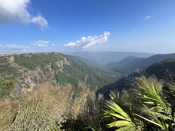
Twenty kilometers from Tura, on the forested slopes of West Garo Hills, lies Selbalgre—a village of roughly 800 souls who've done something extraordinary. They've voluntarily set aside over 600 hectares of their ancestral land not for profit, not for tourism, but for a creature they call Huro: the Western hoolock gibbon, India's only ape.

On December 12, 2025, the Garo Hills Autonomous District Council (GHADC) made it official: Selbalgre Village Wildlife Reserve became a formally protected area, one of 40 Village Reserve Forests (VRFs) now covering 6,753 hectares across the Garo Hills. But the real story began decades earlier, rooted not in legislation but in legend—a Garo belief that if you kill a hoolock gibbon, your entire village will be cursed (Shillong.com, 2026; Wildlife Trust of India, 2025).

This isn't eco-tourism theater. This is community-led conservation in its purest form—where cultural reverence meets ecological crisis, and where morning gibbon calls aren't just sounds, but sacred omens.


The Huro: India's Singing, Swinging Endangered Ape

Meet the Western Hoolock Gibbon

Scientific name: Hoolock hoolock
IUCN Status: Endangered
Global Population: Fewer than 5,000 individuals
India's Population: ~200–300 groups (concentrated in Assam, Meghalaya, Arunachal Pradesh, Nagaland)

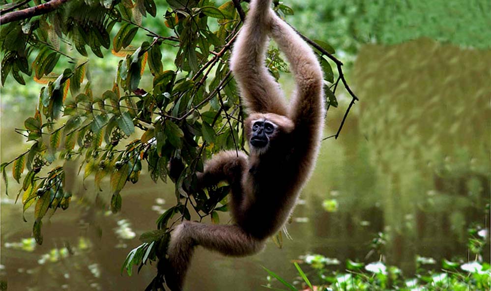
The Western hoolock gibbon is a marvel of evolution—tailless primates weighing 6–9 kg, with arms so long they can brachiate (swing) through forest canopies at speeds reaching 55 km/h. Males are jet-black with prominent white eyebrows (hence the nickname "white-browed gibbon"); females are golden-buff with darker faces. Their morning duets—haunting, melodious calls that echo across the hills—serve to mark territory and strengthen pair bonds (New England Primate Conservancy, 2023; Wikipedia, 2026).

In Garo culture, the gibbon isn't just wildlife—it's Huro, a spiritual guardian. Villages with sacred groves believe the gibbon's calls bring good fortune; a call near the village is an omen of prosperity. To kill a gibbon is to invite calamity upon the entire community—a taboo so powerful that it's protected these apes for generations even without legal status (Gibbons Asia, 2024; WTI, 2025).

Why They're Endangered

The Western hoolock gibbon faces existential threats across its range:

  • Habitat loss: Jhum cultivation (slash-and-burn farming), coal mining, infrastructure development
  • Fragmentation: Isolated forest patches can't support viable populations; gibbons need contiguous canopy for movement
  • Hunting: Though illegal, capture for pet trade persists in some areas
  • Low reproductive rate: Females give birth to single offspring every 2–3 years, with long juvenile dependency

In Meghalaya, rapid loss of tropical evergreen and semi-evergreen forests has pushed gibbons into shrinking habitat islands. A 2006 study noted dramatic declines across Northeast India, with Meghalaya's gibbon populations particularly vulnerable (Choudhury, 2006; Meghalaya Biodiversity Board, 2017; ScienceDirect, 2021).


Selbalgre: A Living Laboratory of Community Conservation

The Sacred Grove at the Heart

Selbalgre's reserve centers on a sacred grove—a law kyntang in Khasi, or community-protected forest. These groves, common across Meghalaya's tribal communities (Khasi, Jaintia, Garo), are biodiverse refugia where logging, hunting, and even trespassing are culturally forbidden. A 1998 study documented 79 sacred groves in Meghalaya, ranging from 0.01 to 900 hectares, with remarkably high species diversity intact (Tiwari et al., cited in Sacred Earth Trust, 2022).

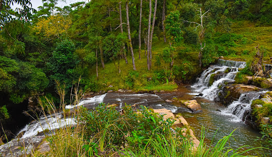
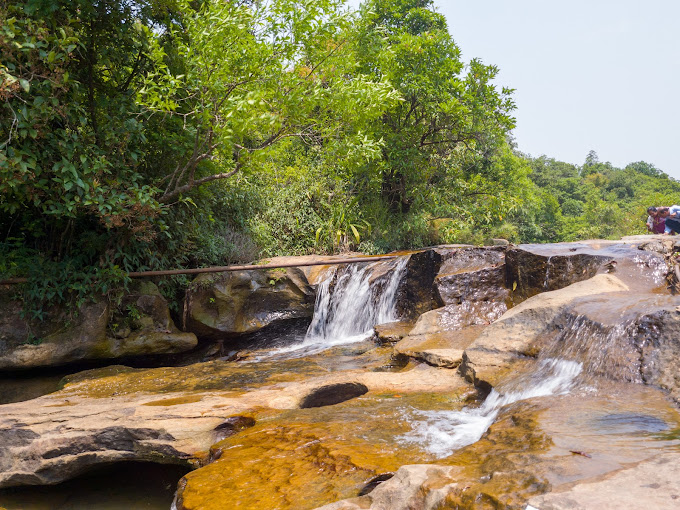
At Selbalgre, the sacred grove functions as core gibbon habitat—dipterocarp-dominated tropical evergreen forest with bamboo understory, providing fruit, flowers, leaves, and insects that gibbons rely on year-round. The villagers maintain buffer zones around the grove, restricting activities that could disturb gibbons during critical breeding seasons (November–March) (Taylor & Francis, 2024).

Community-Led Expansion

In December 2025, Selbalgre villagers pledged an additional 100 hectares to the reserve—bringing the total protected area to approximately 600+ hectares. This expansion wasn't mandated by government; it was driven by village elders (Nokmas) and community consensus, recognizing that gibbon populations need larger, connected territories to thrive (WTI, 2025).

The Huro Programme, a French-Indian conservation partnership founded in 2006, has worked alongside Selbalgre residents to monitor gibbon populations, restore degraded forest corridors, and educate younger generations about Huro's ecological and cultural importance (Palmyre Conservation, 2024).


Visiting Selbalgre: What to Expect

The Experience

Important Reality Check: Selbalgre is NOT a polished ecotourism destination. There are no visitor centers, no marked trails, no cafés. This is a working village with a conservation ethic, not a wildlife theme park. Visits require local guide coordination, respect for cultural protocols, and realistic expectations about gibbon sightings.

What You Might Experience:

  • Early Morning Gibbon Calls (5:30–7:30 AM): The best time to hear hoolock gibbons' haunting duets echoing through the forest—pairs "sing" together to mark territory
  • Forest Trek: Guided walk through sacred grove and community forest (2–4 hours); steep, muddy trails; moderate fitness required
  • Gibbon Sighting (If Lucky): Gibbons are arboreal and elusive; visual sightings depend on season, weather, and luck. Hearing them is more common than seeing them
  • Cultural Interaction: Meet villagers, learn about Garo traditions, sacred grove protocols, and community conservation efforts

Success Rate for Sightings: Moderate. Morning calls are almost guaranteed November–March (breeding season); visual sightings occur in ~30–40% of treks, per anecdotal reports from field researchers (Karger, 2013; ResearchGate, 2013).

Practical Information

Location: Selbalgre village, West Garo Hills District, Meghalaya
Distance from Tura: 20 km (40 minutes by road)
Nearest Airport: Guwahati (Lokpriya Gopinath Bordoloi International Airport), ~220 km
Nearest Railway: Guwahati Railway Station, ~230 km

Getting There:

  • From Guwahati: Taxi to Tura (5–6 hours, ₹7,000–₹8,500); then local taxi/jeep to Selbalgre (₹500–₹800)
  • From Shillong: Taxi to Tura (121 km, 3 hours, ₹2,500–₹3,500); then local transport
  • From Tura: Hire local guide/driver (arrange through homestays or GHADC tourism office)

Entry & Permits:

  • Entry Fee: None officially listed (as of 2026); community may request nominal donation (₹100–₹200/person) for conservation fund
  • Guide Mandatory: Local guide required (₹500–₹1,000/day); arranging through village Nokma or homestay is standard
  • Permits: No special permits for Indian citizens; foreign nationals should check with Meghalaya Tourism (Protected Area Permits may apply)

Best Time to Visit:

  • November–March: Peak season. Gibbon breeding/calling activity highest; weather dry and pleasant (10–20°C)
  • April–May: Hot (20–30°C) but still viable; reduced gibbon activity
  • June–September: Monsoon. Heavy rains, slippery trails, leeches; gibbons less vocal; not recommended

What to Bring:

  • Sturdy hiking boots (trails muddy year-round)
  • Leech socks/salt (monsoon/post-monsoon essential)
  • Binoculars (for distant gibbon sightings)
  • Water, snacks (no facilities in forest)
  • Insect repellent, sunscreen, hat
  • Respectful clothing (cover shoulders/knees when entering village/sacred areas)

Accommodation

In Selbalgre: Very basic homestays available (₹500–₹800/night); arrange in advance through local contacts or GHADC tourism
In Tura (recommended base): Range of options—budget guesthouses (₹800–₹1,500), mid-range hotels (₹1,500–₹3,000); Tura offers ATMs, restaurants, supplies

Sample Itinerary (2 Days):

  • Day 1: Arrive Tura → Lunch → Drive to Selbalgre → Evening village walk → Overnight homestay
  • Day 2: Pre-dawn wake (5:00 AM) → Gibbon-watching trek (5:30–9:30 AM) → Breakfast → Return to Tura → Optional: Tura Peak/Nokrek side trips

Conservation Context: Why Selbalgre Matters

A Model for Community-Based Protection

Selbalgre represents a paradigm Wildlife Trust of India (WTI) and other conservation bodies are trying to replicate: devolving conservation responsibility to communities who've stewarded these landscapes for centuries. Unlike top-down Protected Areas (national parks/sanctuaries) that can alienate local populations, Village Reserve Forests harness existing cultural reverence and traditional knowledge.

The results speak:

  • 40 VRFs notified across Garo Hills (as of December 2025), covering 6,753 hectares
  • Habitat restoration: 200 hectares of degraded forest reconnected via community-planted corridors
  • Zero reported gibbon killings in Selbalgre for decades (contrast with hunting pressures elsewhere in Northeast India)

On December 4, 2025, over 35 Nokmas (village headmen) from Garo Hills received recognition for their conservation leadership—a rare acknowledgment that traditional authority structures can be powerful allies in biodiversity protection (WTI, 2025; The Shillong Times, 2025).

The Bigger Picture: Meghalaya's Gibbon Populations

Meghalaya hosts one of India's critical Western hoolock gibbon populations, second only to Assam's Hollongapar Gibbon Sanctuary (20.98 sq km, ~125 gibbons). Selbalgre, alongside nearby reserves like Nokrek Biosphere Reserve and community forests in Khasi Hills, forms a fragmented but vital meta-population.

However, challenges persist:

  • Infrastructure projects: New roads fragment canopy; gibbons won't cross open ground
  • Coal mining expansion: Garo Hills' coal-rich geology attracts extraction that degrades habitat
  • Climate change: Shifting rainfall patterns affect fruiting cycles gibbons depend on
  • Limited resources: Community reserves operate on shoestring budgets; enforcement relies on voluntary compliance

A 2021 study modeling gibbon conservation status warned that without landscape-level connectivity and sustained community engagement, localized extinctions are likely by 2050 (ScienceDirect, 2021).


Cultural Threads: The Garo and Their Huro

Legends and Lore

Garo oral tradition holds that the hoolock gibbon once lived among humans, serving as messengers between the mortal and spirit worlds. When a great calamity befell the earth, the gibbons retreated to the forest, their mournful calls a reminder of the severed bond. To harm a gibbon is to anger ancestral spirits—a belief so ingrained that even non-animist Christian Garos often maintain the taboo (Gibbons Asia, 2024).

One elder from Selbalgre recounted: "Our grandfathers told us: the forest is alive because Huro is there. If Huro's voice goes silent, the forest will die, and we will follow" (Village Square, 2024).

Conservation Through Culture

This spiritual framework has proven more durable than legal protection alone. In areas without cultural prohibitions, gibbon populations have crashed despite Schedule I status under India's Wildlife Protection Act (1972). Selbalgre's success underscores a critical conservation principle: lasting protection emerges from within communities, not imposed from outside.

The Huro Programme's approach—combining traditional knowledge workshops, youth education, and alternative livelihoods (ecotourism, sustainable forestry)—offers a replicable model for primate conservation across Southeast Asia's biodiversity hotspots (Huro Programme, 2024; Sierra Club, 2023).


The Harsh Reality: Is Selbalgre Worth Visiting?

Visit Selbalgre if you:

  • Are genuinely interested in community conservation and cultural ecology (not just "ticking off" wildlife)
  • Have realistic expectations: gibbon sightings are NOT guaranteed; hearing calls is the primary experience
  • Enjoy off-the-beaten-path travel, basic facilities, authentic village interactions
  • Want to support grassroots conservation with your visit (tourism income directly benefits reserve maintenance)

Skip (or reconsider) if you:

  • Expect Kaziranga/Ranthambore-level infrastructure and guaranteed sightings
  • Aren't comfortable with muddy jungle treks, leeches, basic homestays
  • Can only travel during monsoon (June–September)—experience severely compromised
  • Prioritize photography over experience (dense canopy makes gibbon photography extremely difficult)

Honest Assessment: Selbalgre is for conservation-minded travelers, not casual wildlife tourists. The experience is humbling, educational, and culturally enriching—but it demands patience, flexibility, and respect for a community that's chosen gibbons over development.


Essential Information at a Glance

CategoryDetails
LocationSelbalgre village, West Garo Hills, Meghalaya
Distance from Tura20 km (~40 minutes)
Distance from Shillong141 km (~3.5 hours via Tura)
Distance from Guwahati~220 km (~6 hours via Tura)
Reserve StatusVillage Wildlife Reserve (GHADC-notified, Dec 2025)
Area~600+ hectares (expanding)
Key SpeciesWestern hoolock gibbon (Hoolock hoolock)
Best Time to VisitNovember–March (gibbon breeding season, dry weather)
Entry FeeNone official; nominal community donation ₹100–₹200
Guide RequirementMandatory; ₹500–₹1,000/day (arrange via village or homestay)
Typical Trek Duration2–4 hours (early morning start, 5:30–9:30 AM)
DifficultyModerate (steep, muddy trails; basic fitness required)
AccommodationSelbalgre homestays (₹500–₹800); Tura hotels (₹800–₹3,000)
Mobile NetworkLimited (Airtel/Jio work in Tura; spotty in Selbalgre)
ATMNearest in Tura (20 km)
PermitsNone for Indian citizens; foreigners check Meghalaya Tourism

Contacts:

  • GHADC Tourism Office, Tura: +91-3651-222001
  • Meghalaya Tourism: www.meghalayatourism.in
  • Huro Programme: www.huroprogramme.org

Voices from the Field

Researcher Perspective

Dr. Salvador Lyngdoh, Wildlife Institute of India researcher who studied Selbalgre's gibbon ecology, noted: "What makes Selbalgre remarkable isn't just the gibbons—it's the seamless integration of conservation into daily village life. Children grow up knowing Huro's calls; they learn territory boundaries not from textbooks but from elders. This is biocultural conservation in action" (WII Digital Repository, 2024).

Visitor Account (Facebook, 2019)

Prokriti Travels: "Selbagre Hoolock Gibbon Reserve—This small area protected by the community is home to the Hoolock Gibbons, the only ape species found in India. The early morning calls echoing through the mist-covered forest, the sight of a gibbon family brachiating through the canopy—it's a privilege to witness this, knowing the villagers have sacrificed economic opportunities to keep it alive" (Facebook, 2019).

Local Voice

A Selbalgre villager, interviewed by Sierra Club (2023): "People ask why we don't cut the forest for fields or coal money. We tell them: Huro is our wealth. When tourists come and see what we protect, they understand—some things are worth more than money" (Sierra Club, 2023).


Beyond Selbalgre: Nearby Attractions

Tura Peak (4 km from Tura):
Moderate trek; 360° views of Garo Hills and Bangladesh plains

Nokrek Biosphere Reserve (45 km):
UNESCO reserve; Citrus indica gene sanctuary; red pandas, clouded leopards

Balpakram National Park (167 km):
"Land of the Dead" in Garo mythology; tigers, elephants, red pandas; dramatic gorges

Siju Bat Cave (117 km from Tura):
India's 3rd-longest cave system; massive bat colonies

Sample 4-Day Garo Hills Itinerary:

  • Day 1: Guwahati → Tura → Tura Peak sunset
  • Day 2: Selbalgre gibbon trek (pre-dawn) → Nokrek Reserve visit
  • Day 3: Drive to Balpakram → Wildlife spotting → Camp/Baghmara stay
  • Day 4: Siju Cave → Return Tura/Shillong

The Verdict: A Pilgrimage, Not a Safari

Selbalgre Hoolock Gibbon Reserve isn't about guaranteed wildlife encounters or Instagram-worthy photos. It's about bearing witness to a community that's chosen ecological stewardship over extraction—in a world where such choices are increasingly rare.

The Western hoolock gibbon, with fewer than 5,000 individuals left, teeters on the edge. Selbalgre's 800 villagers can't save the species alone. But they're holding the line, one sacred grove at a time, proving that conservation driven by culture and respect can endure where laws alone fail.

If you visit, go humbly. Listen for the Huro's call in the dawn mist. Thank the community. Support their homestays and guides. And carry their story back—because the world needs more Selbalgres.


References & Sources


Article researched and written January 2026. All details subject to change; verify current information before travel.

Location
Highlight
No

Shillong Peak: Where Heaven Touches Earth

SHILLONG PEAK
SHILLONG PEAK
SHILLONG PEAK
Audio
SoundHelix-Song-1.mp3
0:00 / 0:00

The Navel of Heaven: Myth Meets Modernity

High above the mist-wrapped valleys of Meghalaya, where the wind carries whispers of ancient legends, stands U Lum Sohpetbneng—the Navel of Heaven. At 6,449 feet above sea level, Shillong Peak isn't just Meghalaya's highest point; it's a sacred threshold where Khasi mythology collides with 21st-century military technology, creating one of India's most intriguing viewpoints Meghalaya Tourism.

The peak's name, Lum Sohpetbneng, translates to "the navel of heaven" in the Khasi language. According to ancient folklore, this summit was once connected to the heavens by Ka Jingkieng Ksiar—a golden ladder (or bridge, depending on who tells the story)—allowing humans and gods to meet freely. But pride and hubris severed this divine connection, leaving only the mountain as a reminder of paradise lost Indian Culture.

Today, an Indian Air Force radar station crowns the peak, its white domes scanning skies that once supposedly bridged worlds. It's a surreal juxtaposition: pilgrims seeking blessings share space with military personnel guarding borders, while tourists navigate between the sacred and the strategic Wanderlog.


The Journey: 10 Kilometers to the Top of Meghalaya

Getting There:
Shillong Peak sits approximately 10 kilometers south of Shillong city center, a 30-40 minute drive through winding roads lined with pine forests and occasional roadside vendors selling local honey and bamboo handicrafts Meghalaya Tourism.

Transport Options:

  • Taxi: Most common option. Round-trip fare ranges from ₹300-₹500 depending on negotiation skills and season WanderOn.
  • Self-Drive: Possible via the Laitkor route; parking available at the base for ₹30 per vehicle.
  • Guided Tours: Many operators combine Shillong Peak with Elephant Falls, Shillong Golf Course, or Don Bosco Museum for half-day circuits.

The final stretch involves a steep climb to the observation area—manageable but expect to catch your breath at this altitude.


What Awaits: Views Worth the Climb

360° Panoramic Splendor:
On clear days (primarily March-May and September-November), Shillong Peak delivers some of Northeast India's most spectacular vistas TripAdvisor:

  • North: The Shillong plateau unfolds like a green quilt stitched with silver rivers
  • Northeast: Distant Himalayan peaks play hide-and-seek with clouds
  • South: The Bangladesh plains stretch to the horizon—a reminder that borders blur from high enough
  • West: The dense Khasi Hills roll into infinity

Two Observation Towers offer slightly different perspectives. The main tower, maintained by the Air Force, provides the highest vantage point. A second, civilian-friendly tower allows closer interaction without security restrictions.

The Photography Paradox:
Here's the catch: you must surrender cameras and mobile phones at the entry gate due to the military installation Meghalaya Tourism. However, authorities allow photography from designated civilian viewpoints—so your phone will be returned for those precious Instagram moments. Just don't aim toward the radar equipment.

TripAdvisor reviewer Anita M (2026) writes: "The view is absolutely worth the camera surrender hassle. Just cooperate with security, and you'll get stunning shots from the permitted areas."


Practical Information: Before You Go

Entry Requirements:

  • Valid Photo ID mandatory (Aadhaar, Passport, Driver's License)—no exceptions
  • Entry Fee: ₹50-₹75 per person (varies by season and authority)
  • Parking: ₹30 per vehicle
  • Timings: 9:00 AM - 3:30 PM
  • Closed: Wednesdays Indian Holiday

What to Bring:

  • Valid ID (cannot stress this enough!)
  • Layers—temperatures drop, and winds pick up
  • Cash (no card machines on-site)
  • Water bottle
  • Sunscreen and sunglasses

What to Expect:

  • Visit Duration: 30 minutes for quick views; 1-2 hours to explore, have tea, and soak in the atmosphere
  • Facilities: Basic tea stalls, small souvenir shops, restrooms
  • Accessibility: Not wheelchair-friendly; involves stairs and uneven terrain


Best Time to Visit: Chasing Clear Skies

Prime Months: March-May and September-November CaptureATrip

  • Crystal-clear skies
  • Comfortable temperatures (10-20°C)
  • Low humidity

Avoid: June-September (monsoon)—visibility drops to near zero with thick fog. You'll see clouds, not views.

Time of Day:

  • Sunrise (6:00-7:30 AM): Best light, fewer crowds—but peak opens at 9 AM, so catch sunrise from nearby Laitkor viewpoint
  • Late Morning (10:00-11:30 AM): Clearest visibility
  • Late Afternoon (2:00-3:00 PM): Golden hour light, but arrive early as the gate closes at 3:30 PM


The Sacred Dimension: Respect & Reverence

While Shillong Peak is now a tourist attraction, it remains sacred to the Khasi community Britannica. The mythology of Ka Jingkieng Ksiar (the golden ladder) is still taught in local schools, and elders occasionally visit to pay respects.

Cultural Etiquette:

  • Dress modestly
  • Avoid loud music or disruptive behavior
  • Don't litter (carry back all waste)
  • If you see locals performing rituals, observe from a respectful distance


Nearby Attractions: Building Your Itinerary

Within 15-20 km:

  • Elephant Falls (7 km): Three-tiered waterfall, perfect morning stop
  • Shillong Golf Course (12 km): "Gleneagles of the East," worth a walk-through
  • Don Bosco Museum (8 km): 7-storey cultural deep dive
  • Umiam Lake (17 km): Scenic reservoir, water sports

Sample Half-Day Itinerary (9 AM - 2 PM):

  1. 9:00 AM: Elephant Falls (1 hour)
  2. 10:30 AM: Shillong Peak (1.5 hours)
  3. 12:30 PM: Lunch in Laitkor village
  4. 1:30 PM: Golf Course walk or return to city


Visitor Testimonials: What Travelers Say

From TripAdvisor (2026):
"The views are phenomenal if you get lucky with weather. The ID and camera surrender felt strange at first, but security was professional. Go on a weekday to avoid crowds."Rajiv S, Mumbai

"Mythology + military + mountains = Shillong Peak! Don't expect Instagram-ready photo ops everywhere, but the permitted viewpoints are gorgeous."Priya K, Bangalore TripAdvisor

From Wanderlog (2025):
"Visited in April—visibility was perfect. Could see the Bangladesh plains clearly. Tea stall chai hit the spot after the windy observation deck!" Wanderlog


The Verdict: Is Shillong Peak Worth It?

Yes—with caveats.

If you're in Shillong, a trip to the peak is essential for:

  • View chasers seeking Meghalaya's rooftop perspective
  • Culture enthusiasts intrigued by Khasi mythology
  • Photographers willing to work within restrictions
  • Families looking for accessible high-altitude experiences

Skip if:

  • It's monsoon season (you'll see nothing)
  • You're photography-obsessed and frustrated by restrictions
  • You're visiting on a Wednesday (it's closed!)


Final Tips: Making the Most of Your Visit

  1. Check weather forecasts on shillong.com before heading out
  2. Arrive early (9:00-10:00 AM) for the best light and fewer tour groups
  3. Carry exact change for entry and parking
  4. Combine with Elephant Falls for an efficient morning
  5. Hire a local guide (₹200-300) to hear authentic Khasi stories
  6. Respect the military presence—cooperate with security, and the experience will be smooth


Essential Details at a Glance

DetailInformation
Altitude6,449 ft (1,965 m)
Distance from Shillong~10 km
Entry Fee₹50-75 per person
Parking₹30 per vehicle
Timings9:00 AM - 3:30 PM (Closed Wednesdays)
ID RequiredYes, mandatory
PhotographyPermitted at designated viewpoints only
Best TimeMarch-May, September-November

Sources & Further Reading


Next in Series: Laitlum Canyons | Comprehensive Meghalaya Travel Guide


For real-time weather updates, taxi bookings, and local guides, visit shillong.com.

Location
Highlight
Yes

LADY HYDARI PARK: SHILLONG'S GARDEN OF TWO NAMES

LADY HYDARI PARK Shillong, East Khasi Hills, Meghalaya
Audio
SoundHelix-Song-1.mp3
0:00 / 0:00

A Park, Two Identities, One Story

In the heart of Shillong, where colonial history meets contemporary cultural pride, lies a verdant sanctuary that answers to two names. To longtime visitors and taxi drivers, it's Lady Hydari Park—a British-era garden honoring the wife of a colonial governor. To the Meghalaya government and Khasi cultural activists, it's Ka Phan Nonglait Park, renamed in 2023 to commemorate the first Khasi woman who dared to resist British rule The Shillong Times.

This Japanese-style landscaped garden, established in 1937 under Governor Sir Robert Neil Reid, is more than just Shillong's prettiest park—it's a living testament to the city's evolving identity, where rhododendrons bloom alongside debates about heritage and memory Central Zoo Authority.


Colonial Roots: The Lady Behind the Original Name

Lady Hydari Park was named after the wife of Sir Muhammad Saleh Akbar Hydari, who served as Governor of Assam from 1937 to 1942. Lady Hydari was known for her love of nature and social welfare initiatives, and the park was created as a tribute to her contributions to the region Assam Holidays.

The park's design reflects the Japanese landscaping aesthetics popular during the late colonial period, featuring:

  • Meticulously manicured lawns
  • Ornamental ponds with stone bridges
  • Flowering shrubs arranged in geometric patterns
  • Winding pathways designed for contemplative walks

For decades, it served as Shillong's premier public garden—a place where British officers, local elites, and eventually everyday families came to escape the city's hustle.


The Renaming Movement: Honoring Ka Phan Nonglait

In November 2017, the Khasi Students' Union (KSU) began demanding that the park be renamed to honor Ka Phan Nonglait, a legendary Khasi freedom fighter who revolted against British colonial forces in the 19th century. She is celebrated as the first Khasi woman to take up arms against the Empire Highland Post.

The movement gained momentum:

  • April 2018: KSU activists physically removed the "Lady Hydari Park" signboard and installed a new one reading "Phan Nonglait Park" The Shillong Times
  • May 17, 2023: The Meghalaya State Cabinet officially approved the renaming
  • May 26, 2023: A government notification formalized the park's new identity as Ka Phan Nonglait Park Meghalaya Government

Despite the official change, many locals and tourists still use the old name—a linguistic holdover that reflects the park's dual identity in the public imagination.


The Japanese Garden: A Botanical Wonderland

The park spans several acres in the Laban neighborhood, just 2.5 km from Shillong Bus Stand and an easy walk from Police Bazaar Trawell. Its Japanese-inspired design creates a serene atmosphere:

Flora Highlights:

  • Rhododendrons: Meghalaya's state flower, blooming in vibrant reds and pinks during spring
  • Orchids: Native species displayed along paved walkways
  • Rose Garden: Seasonal roses in multiple hues
  • Ornamental Shrubs: Meticulously pruned into shapes and hedges

Design Elements:

  • Stone bridges arching over lily-pad-dotted ponds
  • Gravel pathways winding through flower beds
  • Japanese rock gardens with carefully placed boulders
  • Wooden benches strategically positioned for optimal views

A TripAdvisor reviewer from 2026 writes: "The garden is beautifully maintained. Perfect for a morning stroll or an afternoon with a book. The rhododendrons were in full bloom when we visited—absolutely stunning!" TripAdvisor


The Mini Zoo: Shillong's Only Wildlife Sanctuary

One of the park's biggest draws is its mini zoo—the only zoological facility in Shillong Indian Holiday. Managed by the Forest Department, it houses:

Mammals:

  • Himalayan Black Bears
  • Deer (multiple species)
  • Serow (goat-antelopes native to the Eastern Himalayas)
  • Tigers (limited enclosures)

Avifauna: 73 bird species, including native pheasants, parrots, and raptors

Reptiles: 140 species, including snakes, lizards, and turtles

While the enclosures are modest by modern zoo standards, they provide a rare opportunity for Shillong residents—especially children—to encounter wildlife without traveling to distant sanctuaries.

Note: Some online reviews from 2025-2026 mention that certain sections of the zoo have been periodically closed for renovation, so check current status before visiting.


The Butterfly Museum: Tiny Wings, Big Wonder

Tucked within the park grounds is a butterfly museum showcasing Meghalaya's rich lepidopteran diversity Shillong.com. The museum features:

  • Preserved specimens of rare butterfly species
  • Educational displays on butterfly life cycles
  • Photography exhibits highlighting Meghalaya's endemic species

Timings: 11:00 AM - 4:00 PM (included in park entry ticket)

For nature photographers and entomology enthusiasts, the museum offers insights into species like the Golden Birdwing and Tawny Coster butterflies found in the region.


Children's Paradise: Play Areas & Activities

Families with young children will appreciate:

  • Playground: Swings, slides, see-saws, and small climbing structures
  • Picnic Areas: Shaded spots with seating for family outings
  • Boating: Small boats available for rides on the park's ponds (seasonal)
  • Open Lawns: Safe spaces for kids to run around

The park is a popular weekend destination for local families, often buzzing with the sounds of children's laughter and families sharing picnics on the grass.


Practical Information: Plan Your Visit

DetailInformation
Official NameKa Phan Nonglait Park (commonly called Lady Hydari Park)
LocationLaban, Shillong; 2.5 km from Bus Stand; 1.5-3 km from Police Bazaar
Entry Fee₹10-₹20 per person; ₹10 for camera
Timings8:00 AM - 5:00 PM
ClosedMondays
Butterfly Museum11:00 AM - 4:00 PM
Visit Duration1-2 hours
ParkingRoadside only (no dedicated lot)
ToiletsAvailable (₹5 charge)

Best Time to Visit:

  • Season: October to March (pleasant weather, flowers in bloom)
  • Time of Day: 9:00-11:00 AM or 3:00-4:30 PM for optimal light and fewer crowds WanderOn

How to Reach

From Within Shillong:

  • Walking distance from Police Bazaar (1.5-3 km)
  • Taxi/Auto: ₹50-100 from city center
  • Local shared taxis available

From Outside Shillong:

  • By Air: Umroi Airport (Barapani) - 25 km away; taxi to Shillong, then local transport
  • By Train: Guwahati Railway Station - 105 km; 3-hour drive to Shillong
  • By Road: 100 km from Guwahati via NH6 Capture A Trip

Photography Tips

  • Golden Hour: Visit just after opening (8:00-9:00 AM) or before closing (4:00-5:00 PM) for soft, warm light
  • Flowers: Macro lens ideal for orchids and roses
  • Wildlife: Telephoto lens for zoo enclosures (respect animal welfare—no flash)
  • Portraits: Stone bridges and Japanese rock gardens make excellent backdrops

Remember to pay the ₹10 camera fee at the entrance.


Nearby Attractions: Build Your Itinerary

Combine Lady Hydari Park with other Shillong highlights:

Within 5 km:

  • Ward's Lake (2 km): Another colonial-era garden with boating
  • Don Bosco Museum (3 km): Seven-storey cultural museum
  • Cathedral of Mary Help of Christians (2 km): Gothic-style church

Half-Day Itinerary Suggestion:

  1. 9:00 AM: Lady Hydari Park (1.5 hours)
  2. 11:00 AM: Ward's Lake (1 hour)
  3. 12:30 PM: Lunch in Police Bazaar
  4. 2:00 PM: Don Bosco Museum (2 hours)

Visitor Testimonials: What Travelers Say

From TripAdvisor (2026): "A well-maintained park with a beautiful variety of flowers. The mini zoo is small but kids loved seeing the bears and deer. Entry fee is very reasonable. Great spot for a morning walk."Sneha R, Bangalore

"This park is amazing with open spaces and lots of trees. The animals are caged, but I liked the Himalayan black bear most. Walking around is relaxing."Amit P, Delhi TripAdvisor

From Wanderlog (2025): "Despite the zoo closure, the park remains a serene retreat. Affordable entry, well-maintained grounds blooming with seasonal flowers." Wanderlog


Cultural Context: Who Was Phan Nonglait?

Ka Phan Nonglait was a 19th-century Khasi woman who became a symbol of resistance against British colonial expansion into the Khasi Hills. At a time when women rarely participated in armed conflict, she fought alongside male warriors to defend Khasi autonomy.

Her legacy:

  • First documented Khasi woman to take up arms against the British
  • Symbol of indigenous resistance and women's empowerment
  • Honored by modern Khasi cultural organizations as a freedom fighter

The park's renaming reflects a broader movement across India to reclaim public spaces from colonial nomenclature and honor indigenous heroes.


The Verdict: Is It Worth Visiting?

Absolutely—with the right expectations.

Lady Hydari Park (Ka Phan Nonglait Park) is ideal for:

  • Families with children seeking a safe, clean outdoor space
  • Nature lovers who appreciate curated gardens and local flora
  • Photographers looking for colorful backdrops
  • Anyone needing a peaceful escape in central Shillong

Manage Expectations:

  • The zoo is small and enclosures are basic (this isn't a modern safari park)
  • Parking can be challenging during weekends
  • Some facilities (toilets, snack stalls) are basic

For the modest entry fee (₹10-20), it's a worthwhile addition to any Shillong itinerary—especially combined with nearby attractions.


Final Tips

  1. Visit on weekdays to avoid weekend crowds
  2. Bring cash (no card payment facilities)
  3. Carry water and snacks (limited food options inside)
  4. Respect the animals—don't tap on enclosures or throw food
  5. Check butterfly museum timings (11 AM-4 PM; may close for lunch)
  6. Use the official name "Ka Phan Nonglait Park" when asking for directions from younger locals—they'll appreciate it

Sources & Further Reading

Location
Highlight
No

Shillong Dotcom brings news, views, business, tourists into one platform.  

Address: Shillong Dotcom, c/o: Online Tent Service Centre, Pynthorbah Block 2 Church Street Shillong - 793001, Meghalaya. INDIA.

For inquiries, collaboration, please contact us at: office@shillong.com, sam@shillong.com. Phone: 6033091345.